WRA · WRI Aqueduct · WWF Water Risk Filter

Water risk and efficiency, from baseline to management blueprint.

From intake to discharge, watershed to wastewater, a structured assessment that turns water data into a multi-year management blueprint. Operators use it daily. Investors use it in due diligence.

Industrial estates in Indonesia face growing water stress, from seasonal scarcity, upstream competition, and declining water quality. Yet most estate operators have only a rough idea of their total water balance, let alone the watershed-level risks that could disrupt operations in the next decade.

  • Invisible water losses Leaks, unmetered withdrawals, and untracked recycling mean the real water balance is always worse than the spreadsheet says.
  • Watershed blind spots Site-level data tells you nothing about upstream diversions, climate-driven flow changes, or competing users in the same catchment.
  • Regulatory tightening PROPER water scoring is getting stricter. Investors are asking for water due diligence. Waiting until the regulation lands is a cost multiplier.

MUSA's Water Assessment is a structured program that starts with a baseline study (water balance, quality mapping, regulatory review), layers in satellite and remote-sensing water risk data (WRI Aqueduct, WWF Water Risk Filter), and produces a multi-year water management blueprint. The result is both a compliance document and an operational tool, estate operators use it daily, and investors use it in due diligence.

The assessment integrates with the MUSA pipeline: sensor data from intake and discharge points feeds the water balance in real time, while satellite-derived risk layers provide the watershed context that site data alone can't capture. The blueprint isn't a PDF that gathers dust, it's a living dashboard with tracked KPIs, CAPEX milestones, and annual review cycles.

Whether you're an industrial estate operator managing 50 tenants, a palm oil mill facing seasonal water scarcity, or a mining company preparing for investor ESG due diligence, the assessment scales to your context.

What we assess

Six dimensions of water risk and efficiency.

Water balance

Intake, use, recycle, discharge, losses, reconciled across the entire site or estate.

Water quality mapping

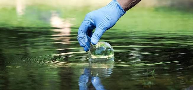
Surface water, groundwater, and effluent quality, spatial and temporal patterns.

Water stress & risk

WRI Aqueduct baseline water stress, seasonal variability, and climate projections.

Regulatory compliance

Permit status, upcoming regulations, PROPER water scoring readiness.

Efficiency benchmarking

Water intensity (m³ per unit output) vs industry peers and best practice.

Stakeholder & community impact

Downstream users, community water access, and shared catchment dependencies.

Benefits

Compliance is the floor, strategic water management is the point.

Watershed-level risk visibility, not just site-level

See upstream diversions, climate projections, and competing users in your catchment, not just what's happening inside the fence line.

WRI Aqueduct and WWF Water Risk Filter integration

Satellite-derived water risk layers ground-truthed with your site data. Global datasets, local calibration.

Multi-year management blueprint with CAPEX/OPEX roadmap

Prioritized interventions with cost estimates, timelines, and expected water savings. A plan you can budget against.

PROPER-ready water management scoring

Assessment outputs map directly to PROPER water criteria. Walk into the rating cycle with evidence, not estimates.

Investor-grade water due diligence package

Standardized risk disclosure format that meets ESG investor expectations. Water risk, quantified and contextualized.

Continuous monitoring after baseline, the assessment becomes a living tool

The baseline isn't a one-off report. Sensor data and satellite feeds keep the assessment current. KPIs update, trends emerge, and the blueprint evolves.

Delivered on the MUSA pipeline

Water Assessment runs across the Sensor, Edge, Warehouse and Platform layers.

01 · SensorFlow meters & quality probes
02 · EdgeMUSA Integrator
03 · WarehouseData Management
04 · PlatformMUSA View
ReportingAssessment reports & blueprint
05 · AgentMUSA Assistant
Features

What's actually in the assessment.

Water balance baseline study

Comprehensive mapping of every water input, use, recycle stream, discharge point, and loss pathway. Metered and unmetered flows quantified. The baseline that every other assessment layer builds on.

  • Intake source inventory (surface, groundwater, municipal, tanker)
  • Process-level water use breakdown by unit operation
  • Recycling rate quantification and loss pathway identification
Water balance baseline study
Water balance · intake to discharge

Watershed risk mapping (WRI Aqueduct)

Overlay your site data with WRI Aqueduct's global water risk layers, baseline water stress, seasonal variability, flood occurrence, drought severity, and upstream storage. Ground-truthed with local hydrological data.

  • WRI Aqueduct baseline water stress score for your catchment
  • Seasonal variability and climate projection scenarios
  • Competing water users and upstream demand trends
Watershed risk mapping
WRI Aqueduct · watershed risk overlay

Efficiency benchmarking dashboard

Compare your water intensity (m³ per ton of product, m³ per employee, m³ per hectare) against industry peers, national benchmarks, and best-available-technology standards. Identify the processes with the highest improvement potential.

  • Water intensity KPIs by process, product line, and tenant
  • Peer benchmarking against industry databases
  • Improvement potential ranking with estimated savings
Efficiency benchmarking dashboard
Water efficiency · benchmark dashboard

Multi-year management blueprint. CAPEX/OPEX roadmap

The deliverable that turns assessment into action. Prioritized water management interventions with cost estimates, implementation timelines, expected water savings, and KPI targets. Structured as a 3–5 year rolling plan.

  • Prioritized intervention list with cost-benefit analysis
  • CAPEX schedule (infrastructure) and OPEX schedule (operations)
  • Annual KPI targets and review cycle built in
Management blueprint and roadmap
Management blueprint · CAPEX/OPEX roadmap
Process

From first meeting to blueprint delivery in 8–14 weeks.

01

Data collection & site assessment

Water permit review, meter inventory, intake/discharge mapping, stakeholder interviews. Site walk and data gap analysis.

02

Water balance & quality baseline

Flow measurement campaign, quality sampling, recycling rate quantification. Build the site-level water balance model.

03

Risk modeling & blueprint development

WRI Aqueduct overlay, efficiency benchmarking, intervention prioritization. Draft the multi-year management blueprint.

04

Implementation roadmap & continuous monitoring

Final blueprint handoff, CAPEX/OPEX plan, KPI framework. Optional: sensor deployment for ongoing monitoring and annual review.

Who it's for

Industries where water risk is a strategic concern.

Industrial Estates

Kawasan · multi-tenant water management

Palm Oil

POME, seasonal scarcity

Textile

High water intensity, dye effluent

Food & Beverage

Process water, CIP cycles

Mining

Dewatering, tailings, community impact

Pulp & Paper

High volume, fiber recovery

Built with

Related products in the MUSA stack.

Other solutions

Compliance across every parameter.

Get started

Tell us about your water context.

One scoping call and a permit inventory is enough to come back with an assessment plan and budget. We work with the meters and data you already have.